The Importance of Farm Field Boundaries
One of our major initiatives this year has been to support the Taylor Geospatial Engine’s first Innovation Bridge program, which is a program designed to accelerate commercialization of geospatial research efforts. In this first iteration of the Innovation Bridge program, we are working to accelerate the practical usage of farm field boundary data by advancing the methods behind creating a global scale field boundaries dataset.
Our work has largely centered on the development of a common data schema for field boundary data that we call fiboa and which we’ve blogged about extensively on the Cloud-Native Geospatial Foundation blog. We are in the process of converting public field boundary data into cloud-native formats that adhere to the fiboa standard which you can see by tracking the fiboa tag on Source Cooperative.
This project has given us a good opportunity to demonstrate how Radiant Earth’s initiatives work together – the Cloud-Native Geospatial Foundation is where we work with our community to figure out how to produce more useful data, and Source is where you can see what useful data looks like in practice. This post is going to explain why this matters, because Radiant Earth’s role is to identify the areas where improved access to data can enable cooperation on important global challenges.
The importance of agriculture is summarized bluntly in a recent article by Jonathan Foley from Project Drawdown titled How food and farming will determine the fate of planet Earth:
Agriculture uses more land than anything we do. It is the biggest driver of species extinctions and ecosystem degradation. It is the single biggest user and polluter of water on the planet. And it is among the world’s most significant contributors to climate change.
It’s hard to overstate the impact of agriculture, which is why many sustainability initiatives revolve around finding ways to improve agricultural practices. We all know that you can’t manage what you can’t measure, but when it comes to agriculture, it’s striking that we don’t yet have global consensus on what we’re measuring when we talk about creating a more sustainable global agricultural sector.
The farm field is a good place to start thinking about how to improve agricultural practices. Fields are a foundational unit of property where critical decisions are made such as what to plant, how to fertilize, how to irrigate, and how to insure. If we intend to improve agricultural practices globally, we need to be able to influence decision making at the field level. This isn’t possible if we don’t know where fields are located or how to refer to them.
The overarching goal of our work with the Taylor Geospatial Engine is to create a common way for everyone to share field boundary data at scale. By aligning data sharing efforts, we hope to enable collaboration among the many different groups across the public and private sectors who are working to do things like enable supply chain traceability, encourage regenerative agriculture practices, or provide insurance to smallholder farms.
This won’t be easy though. First of all, what even is a field? Fields sometime contain other fields. The dimensions of fields change over time. They can expand or shrink. They can be destroyed by floods. They can split into smaller fields or combine into larger fields. Our friends at Varda have produced a thorough FAQ explaining their approach to these problems as they’ve developed their FieldID service. One thing we do know about fields is that they are defined by boundaries, which is why we’ve started this work with fiboa which provides a common data schema for field boundaries. For more on our rationale behind this approach, we’ve written a long post on the importance of common data schemas and identifiers on the Cloud-Native Geospatial Foundation blog.
While we acknowledge that this will be hard, we are very excited by the fact that it’s absolutely possible. Thanks to advances in satellite imagery and machine learning, we’re able to use the Common Task Method to improve agricultural practices. Here’s an explanation of the Common Task Method from Tom Kalil in an interview from the Federation of American Scientists:
- Tasks are formally defined with a clear mathematical interpretation
- Easily accessible gold-standard datasets are publicly available in a ready-to-go standardized format
- One or more quantitative metrics are defined for each task to judge success
- State-of-the-art methods are ranked in a continuously updated leaderboard
Let’s see how this applies to the process of using computer vision to identify global field boundaries:
- Our task is to create a model that can identify field boundaries based on openly available satellite imagery.
- We have abundant public ground truth field boundary data provided by multiple governments or NGOs that we can use to train these models. We are in the process of converting these data into fiboa in order to standardize it.
- We can measure the accuracy of model outputs based on satellite imagery relative to the ground truth data.
- We can expect many models to be created to address this task with varying degrees of success, as agricultural practices vary widely throughout the world. It’s possible that a global field detection model may emerge, but it’s likely that different models will be necessary to detect fields in different regions.
Running through this task over time, we should be able to produce larger volumes of interoperable and increasingly accurate global field boundary data that can serve as the basis for unique field IDs such as those created by Varda’s FieldID.
To the extent we succeed in this, the Common Task Method can then be applied again to any number of challenges related to monitoring the impact of decisions being made on farm fields tracked with unique identifiers. For example, we could start developing models that can assess the effectiveness of regenerative agriculture practices or to determine which fields are likely to be on deforested land.
It has been an honor to work on this with the Taylor Geospatial Engine, whose convening power has attracted collaborators from many organizations including Bayer, Microsoft, Planet, Arizona State University, Washington University in St. Louis, and the World Resources Institute. We look forward to adding many more collaborators as fiboa is entirely open to contributions.
Together, we have a tremendous opportunity to enable a more sustainable agricultural system by combining cutting edge computer vision research with practical commercial applications. We believe creating a shared understanding of the fields where all food is produced is the right place to start.
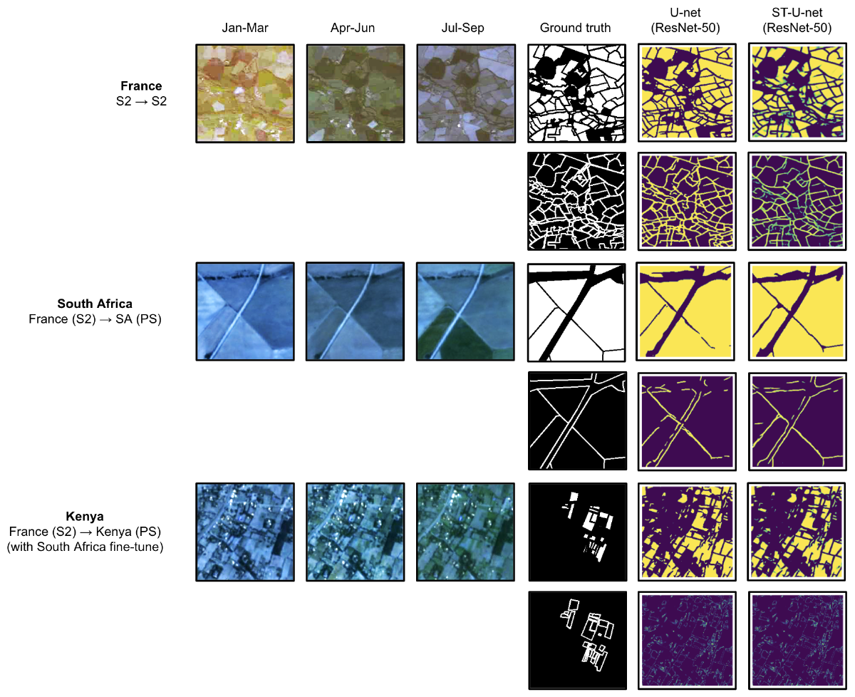
Qualitative field boundary segmentation results for example test images in selected experiments. Credit: Kerner, Hannah et al (2024).